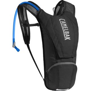
It’s called the Classic for a reason: it’s one of the most enduring and popular of the Camelbak range. It’s not a day pack, it’s a lightweight, minimalist way to carry your water. Full stop. Well, and also your keys, multi-tool, or wallet. Nevertheless, it’s incredibly simple and sleek, and at 170 grams, a pleasure…
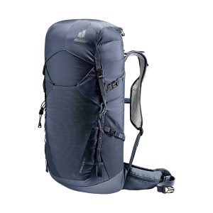
Lightweight and ergonomic, this pack is designed for those who love fast-paced hiking and trail running. Featuring Deuter’s innovative Lite back system, it boasts vest-style, perforated shoulder straps, flexible hip fins, and a precision-adjustable sternum strap-all crafted from 100% recycled, bluesign certified fabric. Keep your essentials close at hand with a convenient pocket on the…
Hema’s regional map of Mid West Western Australia covers from Cape Range National Park south to Mandurah and as far as Kalgoorlie at a scale of 1:1,250,000 that has camping areas, national parks, fuel supplies and facility symbols marked on the map.
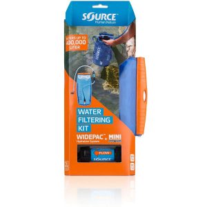
No fiddling with pumps and filters and chemicals. The new Widepac with inline Sawyer filter lets you re-fill your SOURCE from any creek, river, well, lake or pond and be sure to drink clean water. Unless you’re in the desert, this also means: carrying less water, as you are free to refill on the trail!…
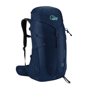
The AirZone at 32 litres is an ideally sized day pack with a female specific Fixed AirZone Carry harness to maximize airflow around your back. The single buckle attachment for the lid makes accessing the main compartment easy whilst side compression straps keep the bag compact. Hip belt pockets make accessing the essentials easy, bungee…
This Cicerone guidebook presents 75 day walks of 1 to 26km in South Africa’s Maloti-Drakensberg Park, a UNESCO World Heritage Site. Located in KwaZulu Natal and easily accessible from Johannesburg, Harrismith, Pietermaritzburg and Durban, the region boasts dramatic cliffs, gorges and waterfalls, abundant wildlife and 2000 year old rock paintings.
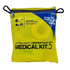
Travel light and fast with the Ultralight/Watertight 5 AMK Medical Kit, which weighs only 102g. With enough first aid supplies for a pair of adventurers heading out for 1-2 days, this 100% waterproof kit is packed with first aid supplies to clean and bandage wounds, treat muscle aches, dress blisters, and treat other common outdoor…
All the mapping you need to complete the 95 mile (153km) West Highland Way, an official Scottish Long Distance Route from Milngavie near Glasgow to Fort William. Showcasing the wild beauty of western Scotland, the trail is a journey from the lowlands to the highlands, passing Loch Lomond then crossing Rannoch Moor before finishing in…
John Chapman and his co-authors spend their lives hiking all over this great land and writing guide books so the rest of us can follow them. Through years of refinement John & Co’s books are well laid-out and colourfully illustrated that detail routes, background, safety, trip planning and further reading.
A comprehensive map of Victoria for touring throughout the state that has camping and rest areas, 24-hour fuel and points of interest marked on the mapping. On the reverse are CBD, the surrounding region and through road maps of Melbourne in addition to maps of the Great Ocean Road and East Gippsland. Also included is…
Hema’s updated WA State Map is comprised of the most detailed information, which has been verified by Hema Map Patrol. It is printed on waterproof paper and includes a full index of locations, making it durable and easy to use for both navigation and inspiration. On the reverse side of the maps are through road…


 Walking the Camino Dos Faros
  West MacDonnell Ranges and Larapinta Trail Map Kit
  Walking and Cycling Canberras Centenary Trail